The tallest building in Dubai is lower than Dubai's own highest mountain, and the UAE's highest point is higher than both. The chart below puts the four heights side by side. Further down, a table shows how high your community sits above sea level, and a free map lets you check any other spot yourself.
Most of the city sits far lower than any of them. The 22 communities in the table run from sea level on the Persian Gulf coast to about 45 m in Dubai South.

Burj Khalifa height above sea level vs Hatta vs Jebel Jais
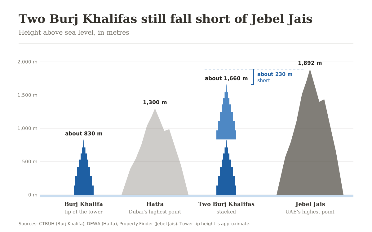
Burj Khalifa is 828 m tall, according to the Council on Tall Buildings and Urban Habitat (CTBUH). Downtown Dubai, where it stands, is only a few metres above the sea. So the tip of the tower is about 830 m above sea level.
Hatta belongs to Dubai, even though it sits far from the city, in the Hajar mountains near the border with Oman. DEWA, the Dubai Electricity and Water Authority, puts its highest summit at 1,300 m above sea level. DEWA calls it the highest natural summit in Dubai. So Dubai's highest point is a mountain top in Hatta, and the tower does not come close to it.
Jebel Jais is in Ras Al Khaimah. Its summit lies across the border in Oman. A high point west of the summit, on the UAE side, is the country's highest point, at about 1,892 m. Put a second Burj Khalifa on top of the first and you reach about 1,660 m. That clears Hatta. It still falls about 230 m short of Jebel Jais.
How high is your Dubai area above sea level?
The table gives the approximate elevation of 22 Dubai communities. Tap a column heading to sort by name or by height. Tap it again to reverse the order.
| Palm Jumeirah | 0 |
| Dubai Marina | 0 |
| JBR | 0 to 3 |
| JLT | 0 to 3 |
| Business Bay | 2 |
| Downtown Dubai | 3 |
| Dubai Creek Harbour | 0 to 3 |
| Al Furjan | 0 to 3 |
| JVT | 6 |
| JVC | 10 |
| Dubai Hills | 15 |
| International City | 15 |
| Dubai Sports City | 22 |
| Damac Hills | 23 |
| Dubai Silicon Oasis | 24 |
| Mirdif | 29 |
| Motor City | 30 |
| Town Square | 35 |
| DLRC | 36 |
| Arabian Ranches 2 | 36 |
| Arabian Ranches 3 | 36 |
| Dubai South | 45 |
The lowest readings are mostly on the coast and the creek. Palm Jumeirah and Dubai Marina read 0 m. JBR, JLT and Dubai Creek Harbour read 0 to 3 m. Al Furjan reads the same, even though it sits further inland. Business Bay is about 2 m up and Downtown Dubai about 3 m.
The land rises slowly as you move inland. JVC reads about 10 m, Dubai Hills and International City 15 m, Damac Hills 23 m and Motor City 30 m. The highest communities in the table all sit well away from the sea: Town Square at about 35 m, DLRC and Arabian Ranches 2 and 3 at about 36 m, and Dubai South at about 45 m.
Check the elevation of any place in Dubai yourself
Every number in the table comes from one free map, the Dubai topographic map on topographic-map.com. It opens in any browser, on a phone or a computer. There is nothing to install and no account to create.
- Open the Dubai map. It opens on the wider region, a little way down the page.
- Zoom in with the plus and minus buttons in the corner, or pinch on a phone, and drag the map to your building or street. Many place names on the map are in Arabic, so use the coastline, the shape of the Palm and road numbers such as E11 to find your way.
- The search box at the top opens the site's map of a named place, such as a city, a park or some communities. When a community has no map of its own, the search opens the whole emirate instead. Zoom in by hand from there.
- Tap or click the exact spot. A small box opens with its elevation in metres.
- The page address changes as you move the map. Copy it and send it, and the map opens on the same spot for the person who receives it.

How to read the colour legend
The legend runs down the right side of the map. Each colour has a height in metres next to it. Blue marks the lowest ground in the view, red and pink the highest.
The scale is not fixed. Every time you zoom or pan, the site fits the colours again to the heights in that view. A pale cyan that means a few metres on the city view means tens of metres once you zoom out to the whole emirate. So never judge a height by its colour. Read the number on the legend in front of you, or tap the spot.
To compare two places on the same scale, tick the small box beside the lock under the legend. The scale then stays put while you move the map, until you untick it.
How these numbers were made
The area figures are readings of that map's colour scale. For each area, I took the median elevation within about 600 m of the area's centre. The median is the middle value: half the ground around the centre is lower and half is higher, so one small mound or dip does not move it. The figures are rounded and approximate. They are not survey levels, and they do not replace the official level of a plot.
Some coastal and built-up spots show slightly below zero on the map. Treat those as sea level.
The mountain heights do not come from the map. It is built on a digital elevation model of the ground, and on sharp summits its readings can come out lower than the official figures. That is why the Hatta figure comes from DEWA and the Jebel Jais figure from Property Finder.
Why elevation is worth knowing when you choose where to live
On its own, height above sea level tells you nothing about a price or about the quality of a community, and I make no such claim here. It is a fixed fact about a location, like the direction a building faces or its distance from a flight path. Knowing it gives you a clearer picture of the city.
That picture is simple. Dubai is built on almost flat ground at sea level along the coast, and the land rises slowly inland. From the lowest community in the table to the highest, the spread is about 45 m. The tip of Burj Khalifa alone stands about 830 m above the sea. If you are choosing between two communities, add the number to everything else you know. For one specific building, spend a few minutes on the map.
Free map checks I run before recommending a unit
Elevation is one of several things you can check for free, in minutes, before you buy or rent. Before I put a unit in front of a client, I run three other public maps. The noise map shows whether it sits under a flight path. The air quality map shows how its air compares with the city average. The shadow map shows where the sun falls, by the hour and by the season.
If you are looking for an investment consultant who weighs all of this before suggesting anything to you, message me on WhatsApp or through the contact page.
Sources
- Elevation map and every figure in the area table: Dubai topographic map, topographic-map.com
- Burj Khalifa, 828 m tall: Council on Tall Buildings and Urban Habitat (CTBUH), The Skyscraper Center
- Hatta, 1,300 m, the highest natural summit in Dubai: Dubai Electricity and Water Authority (DEWA), Hatta hydroelectric power plant news, June 2022
- The UAE's highest point, 1,892 m on Jebel Jais: Property Finder, guide to the mountains of the UAE
All links and figures checked on 12 November 2026.
Frequently asked questions
Most of the city is low. The 22 communities in this article run from 0 m on the coast, at Palm Jumeirah and Dubai Marina, to about 45 m in Dubai South. The emirate's highest point is a summit in the Hatta mountains, 1,300 m above sea level.
A summit in the Hatta mountains, 1,300 m above sea level. DEWA, the Dubai Electricity and Water Authority, calls it the highest natural summit in Dubai. Hatta is part of the emirate of Dubai and sits in the Hajar mountains.
The tower itself is 828 m tall, according to the Council on Tall Buildings and Urban Habitat (CTBUH). Downtown Dubai is only a few metres above the sea, so the tip of the tower is about 830 m above sea level.
A point on Jebel Jais in Ras Al Khaimah, about 1,892 m above sea level. The summit of the mountain itself lies across the border in Oman; 1,892 m is the highest point on the UAE side.
No. Two Burj Khalifas stacked come to about 1,660 m. The UAE's highest point on Jebel Jais is about 1,892 m, so the two towers are still about 230 m short.
Yes. Hatta belongs to the emirate of Dubai, even though it lies far from the city, in the Hajar mountains near the border with Oman. Dubai's highest summit, at 1,300 m, is there.
Of the 22 communities in this article, Dubai South is the highest, at about 45 m. DLRC and Arabian Ranches 2 and 3 follow at about 36 m, then Town Square at about 35 m.
Palm Jumeirah and Dubai Marina read 0 m on the elevation map. JBR, JLT, Dubai Creek Harbour and Al Furjan read 0 to 3 m.
Open the free Dubai map on topographic-map.com, zoom in on your community and tap the exact spot. A small box shows the elevation of that point in metres. It needs no account and no app.
The map fits its colour scale to the heights in each view, so the same colour means a different height in two different views. Always read the number on the legend on screen. To compare two places on one scale, tick the box beside the lock under the legend.
The map is built on a digital elevation model of the ground, and along the coast and among tall buildings it can read slightly below zero. Treat those spots as sea level.
No. Each figure is the median elevation within about 600 m of the area's centre, read from the map's colour scale and rounded. They are approximate, not survey levels, and they do not replace the official level of a plot.