In Dubai, sunlight is not a matter of taste. It is heat. A unit whose main windows take the afternoon sun runs hotter from May to October, its cooling runs longer, and its balcony is too hot to use at 4 pm for months at a time. You can see exactly where the sun falls on any building, at any hour of any day, before you sign. The tool is free, and it works for any address on earth, not only in Dubai.
The short version
- ShadeMap (shademap.app) is free, opens in any browser on a phone or a laptop, and works for any address in the world.
- Search the building, set the date to 21 June and drag the clock to 4 pm. If the windows you care about are lit, that room takes the summer sun at the hottest hour of the day.
- In Dubai, north and east are the cooler sides. West takes the hardest sun, all of it in the afternoon. South barely sees the summer sun and gets it all day in winter.
- The one thing to watch: the map only knows the buildings that exist today. If the plot next door is empty, find out what is approved on it.
What ShadeMap is, and why it works anywhere

ShadeMap simulates the shadows cast by buildings, trees and terrain for any date and any time. The method is simple. From the place and the date, it works out where the sun is in the sky. Then it traces a line from every point on the map toward the sun. If the line hits a building, a tree or a hill, that point is in shade. If it does not, the point is in the sun.
Because the only inputs are a location and a date, it works for the whole planet. The same few clicks that check a tower in Dubai Marina check a flat in London, a house in Toronto or an apartment in Tehran. Building footprints and heights come from OpenStreetMap, Overture and Mapbox, tree canopy from Meta and the World Resources Institute, and terrain from a separate elevation source.
The basic map is free and needs no account. ShadeMap itself puts the error of the free data at 1 to 3 metres. For some cities, Dubai Marina and London among them, there is a premium layer built from LiDAR and aerial surveys, accurate to about 25 centimetres, at US$3.99 per square kilometre. For a decision about one unit, the free map is enough.
Why sunlight is a price question in Dubai
Dubai sits at 25 degrees north, just above the Tropic of Cancer. On 21 June the noon sun stands 88 degrees high, almost straight overhead, and the day lasts 13 hours 42 minutes. The sun rises in the north-east and sets in the north-west. In July and August, afternoons regularly pass 40°C.
In that climate, direct sun through glass is heat. A unit whose main windows face the afternoon sun runs hotter, its air conditioning works longer and the electricity or district-cooling bill goes up. A balcony in full sun at 4 pm is not a place anyone sits between May and October.
Buyers from cooler cities arrive with the opposite instinct. In London, Toronto or Tehran, a bright south-facing flat is the prize, because winter sun warms and lights the home. In Dubai that instinct is half right. Winter sun from December to February is pleasant. Summer sun is the thing to manage. I treat orientation the way I treat noise: as part of the price, not a matter of taste, because an informed tenant or buyer weighs it when you come to rent or sell.
Which side of a Dubai building takes the sun
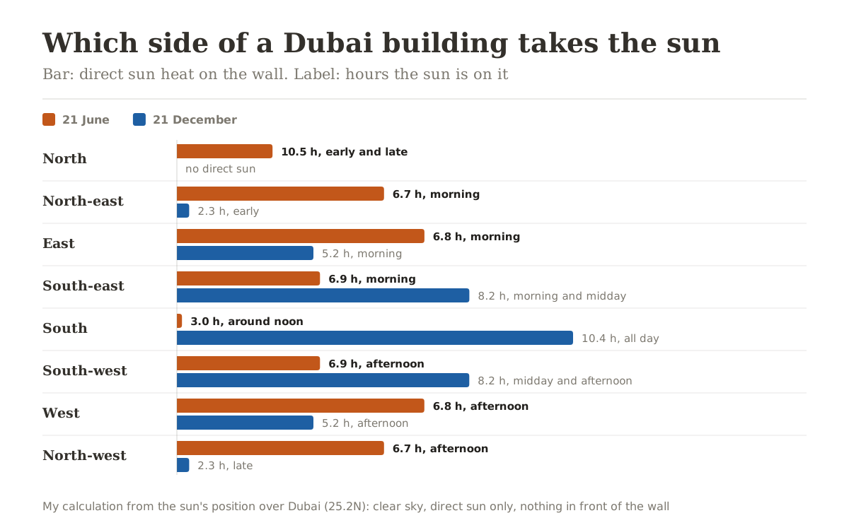
Four things stand out.
West is the hot side. On 21 June a west-facing wall is in direct sun from 12:21 until sunset, almost seven hours, and all of it lands in the hottest part of the day. East gets the same total, but between sunrise and noon, while the air is still cooler.
North is the cool side. In summer the sun reaches it only early and late, at a glancing angle, and it takes less than 40 percent of the heat the west wall takes. From late September to late March, direct sun never reaches a north-facing wall at all.
South flips with the season. In June the sun is almost overhead, so a south wall gets about three hours of steep, glancing sun between 10:50 and 13:53, and a balcony above blocks most of it. On 21 December the same wall is in the sun from 7 am to 5:30 pm, more than any other side.
Sea views face north-west. The Dubai coast runs from south-west to north-east, from Jebel Ali to Deira, so a unit facing the sea in Dubai Marina or JBR usually faces north-west. In summer that side takes direct sun from about 12:30 until sunset. The sunset view and the afternoon heat come through the same window. That is not a reason to skip the unit. It is a reason to ask about the glass, the depth of the balcony and the curtains.
For villas and townhouses, the question is usually the garden and the pool. In winter the sun is low and in the south, so a villa shades its own north garden: at noon on 21 December, an 8 metre, two-storey house throws a shadow about 9 metres long. In summer the noon sun is overhead, and the garden gets almost no shade from the house except early and late. If you want the pool in shade on a July afternoon, something has to stand to its west. The map shows you whether it does.
How to check a unit in five minutes
- Open shademap.app in any browser. There is nothing to install, and on an iPhone you can add it to the home screen from Safari's share menu.
- Type the tower, project or community into the search box, or pan the map to it.
- Zoom out until the tall buildings around it are on screen. The map only calculates shadows from what is on screen, so a tower just outside the frame is ignored.
- Tap the date at the bottom and the timeline switches from hours to months. Drag it to 21 June, then tap the time and drag the hours to 8 am, 12 pm and 4 pm, noting which faces of the building are lit.
- Repeat for 21 December, when the sun is at its lowest and the shadows at their longest.
- Open Layers and pick Hours in the sun to see the total hours of direct sun for that day, in colour.
- For one exact spot, such as a garden, a pool deck or a ground-floor terrace, right-click it on a computer or press and hold on a phone, then choose Annual sunlight.

Same towers, same hour, two seasons. At 4 pm on 21 June the sun is 40.5 degrees high and the shadows are short. At 4 pm on 21 December it is 17.5 degrees high, and the towers throw their shadows across the water. That is why I always check both dates.
The annual sunlight chart for one exact spot

The annual view is a calendar of sun for one spot: every day of the year, and the hours it spends in direct sun. Above it sit two totals, the hours of direct sun in a year and the solar energy per square metre. The street-level spot I picked between the Dubai Marina towers gets 1,420 hours of direct sun a year. Open ground near Global Village, with nothing around it, gets 4,335 on the same tool. The towers take about two thirds of the marina spot's sun.
That number is most useful for low floors, terraces, podium pools and villa gardens. If a garden gets no sun at all in January, or a pool sits in full sun from noon to sunset in July, this chart shows it before you sign, not after.
When the plot next door is still empty
In off-plan Dubai, the plot beside a project is often still sand, and the map only knows today's city. The drawing tool in the top corner fixes that. Draw the outline of the future building, set its height, and its shadow appears on the map. To take a building or a tree out of the calculation, draw over it and set the height to zero.
Ask the developer for the permitted height of the plots around you, or check the masterplan. A tower rising to your west takes the afternoon sun, and probably the view. One rising to your south takes the winter sun. To see what is already launched or under construction around a plot, use my 3D map of every Dubai project.
Four limits to know before you trust the result
- Missing heights. A building with no height in the data is drawn one storey tall, at 3.1 metres. If a tall tower beside your building throws no shadow on the map, its height is missing, and the result needs care.
- Ground level. Shadows are drawn on the ground, not on your floor. For the 30th floor, the question is whether anything taller than your floor stands to your west or south.
- Accuracy. The free data is off by 1 to 3 metres. That is fine for a tower's shadow or a villa garden. For a tighter decision, the premium layer is far more precise.
- What is not modelled. Balcony depth, shading fins, glass tint and glare from a glass tower opposite do not appear on the map. Check those on a viewing, ideally at the hour that matters to you.
Not only Dubai: London, Tehran, anywhere

The same map works for a flat in London, a house in Toronto or an apartment in Tehran, and the logic changes with the climate. At noon on 21 December the sun over London is only 15 degrees high, so a building throws a shadow 3.7 times its own height. There, you pay for sun. In Tehran at the same moment the sun is 31 degrees high and the shadow is 1.7 times the height. In Dubai it is 41 degrees and 1.1 times, and at noon on 21 June a Dubai building casts almost no shadow at all.
If you own property elsewhere, or you are buying for family in another city, the check takes the same five minutes.
Three free checks I run before recommending a unit
Before I put a unit in front of a client, I run three free public maps. The noise map shows whether it sits under a flight path. The air quality map shows how its air compares with the city average. The shadow map shows where the sun falls, by the hour and by the season. None of the three is in a brochure. All three show up in daily life, and at resale.
If you are looking for an investment consultant who weighs all of this before suggesting anything to you, message me on WhatsApp or through the contact page.
Source: shademap.app and its help pages (checked 28 September 2026), and my own sun-position calculations for Dubai, Tehran and London.
Frequently asked questions
ShadeMap is a free online map at shademap.app that simulates the shadows of buildings, trees and terrain for any date and time. The basic version needs no account and no install, and runs on a phone or a computer. For some cities, including Dubai Marina, a premium LiDAR layer accurate to about 25 centimetres costs US$3.99 per square kilometre.
No. It works for any point on earth, because the calculation only needs a location and a date. You can check a flat in London, a house in Toronto or an apartment in Tehran the same way. The only difference between cities is how complete the building height data is.
For a living room or balcony, north and east are the cooler sides. A west-facing wall takes direct sun from 12:21 until sunset on 21 June, almost seven hours, during the hottest part of the day. South barely sees the summer sun and gets it all day in winter. The final choice also depends on the view, the floor and the buildings around you.
Yes, west is the hottest side in summer. On 21 June a west-facing wall takes about 2.6 times the direct sun heat of a north-facing wall, and all of it arrives after midday, when July and August afternoons regularly pass 40°C. Double glazing, a deep balcony and good curtains reduce the effect.
A little in summer, only early in the morning and late in the afternoon, at a glancing angle. From late September to late March, direct sun never reaches a north-facing wall at all. The light on that side is mostly indirect and even, and it is the coolest side of the building in summer.
Usually north-west. The Dubai coast runs from south-west to north-east, so a unit facing the sea in Dubai Marina or JBR faces north-west. That side takes direct sun from about 12:30 until sunset in summer, and only after about 3 pm in winter. The sunset view and the summer afternoon heat come through the same window.
In ShadeMap, open Layers and choose Hours in the sun to see the total hours of direct sun on the date you picked. For one exact spot, right-click it on a computer or press and hold on a phone, then choose Annual sunlight. You get a month-by-hour chart of when that spot is in direct sun, plus its total hours for the year.
Yes. Use the drawing tool in the top corner of the map to draw the building's outline on the plot and set its height, and its shadow is calculated. To remove a building or a tree, draw over it and set the height to zero. This matters for off-plan purchases, where the plots around a project are often still empty.
The site puts the error of its free data at 1 to 3 metres. Buildings with no height in the data are drawn one storey tall, at 3.1 metres, so if a tall tower throws no shadow on the map, read the result with care. For Dubai Marina, a LiDAR layer accurate to about 25 centimetres is available at US$3.99 per square kilometre.
No. Shadows are drawn at ground level. For a high floor, check whether anything taller than your floor stands to your west or south. If nothing does, that floor gets the full sun on that side. For low floors, terraces and villas, the map shows close to what you will experience.
The view usually moves the price more than orientation does. But orientation directly affects cooling costs, how usable the balcony is and how comfortable the unit is in summer, and informed tenants and buyers weigh it. That is why I treat it the way I treat noise, as part of the price, and check it before I recommend any unit.
Aircraft noise and air quality are the other two free checks. The noise map shows whether a unit sits under a flight path, and the air quality map compares a community's air with the city average. I run all three before recommending any unit.
Yes. It runs in the phone's browser and uses the phone's graphics chip, which makes it smooth on any recent phone. On an iPhone, tap Safari's share button and choose Add to Home Screen, and it sits on your home screen like an app.